RoofOfRock web and mobile applications
Matija Krivic, Tadej Fius, Luca Zini, Alessio Mereu


Matija Krivic, Tadej Fius, Luca Zini, Alessio Mereu
One of the outcomes of the RoofOfRock project is a very large volume of collected data. The involvement of different disciplines and fields of research in the project is also reflected in the complexity and quantity of this data. In order to present the results of the project efficiently using this data it was necessary to implement an appropriate data management scheme—for which purpose a common joint database has been implemented.
It was necessary to choose an appropriate database, as the data collected is of various types and formats. The data varies from attributes to spatial data, and from images and documents to textual records. The preferred type of database for this purpose is a relational spatial database or geodatabase, since all of the information is related to specific geographic locations.
The purpose of the geodatabase is, in addition to data management and storage, to serve as a basis for creating various applications, such as map viewers. The database should therefore allow fast and efficient data access. This is achieved with correct structuring and a relational data model. This data model must then follow the concept by which data is presented on the map viewers. The data in the RoofOfRock database is structured as different sections that are interrelated. The user can access different combinations of data, such as descriptions of the studied objects, their individual elements, and related construction materials together with spatial and geological origin.
The RoofOfRock database contains 16 tables and 15 spatial data layers that are structured in three main sections: geology, studied objects as cultural heritage, and natural heritage as limitations and guidelines. The geology section is divided into geological overview data at a scale of 1:250,000 and platy limestone data at a scale of 1:50,000. In the studied objects section is all of the data on the selected objects constructed of platy limestone.
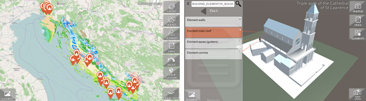
This joint database serves as the basis for the map viewers that also express the outcomes of the project. There are three different types of map viewers or applications created as outcomes of the project: a stand-alone desktop GIS map viewer, a web application, and a mobile application with augmented reality. All applications are designed to represent the use of platy limestone in the construction of buildings through cultural heritage. The desktop GIS application allows the user to directly view and query all of the collected data and their relations, and is available as an annex to this report. The web application is available at http://roofofrock.units.it/. It also allows the user to view and query all of the data, and provides the user with information related to limitations and guidelines on the use of play limestone. The mobile application has been created for smart phones and tablets on both Android and iOS platforms. Along with basic browsing and query features this mobile application also includes a so-called augmented reality feature, which displays 3D models of selected objects and their platy limestone elements. It is available for download at Google Play and Apple App store.