RoofOfRock web and mobile applications
Matija Krivic, Tadej Fius, Luca Zini, Alessio Mereu


Matija Krivic, Tadej Fius, Luca Zini, Alessio Mereu
In creating the RoofOfRock geodatabase process two types of geodatabase were used. The file geodatabase was used to design, create and test the RoofOfRock geodatabase. It was used also in the final deployment of the stand-alone desktop GIS application as a data storage location. The final version of RoofOfRock was deployed as an Enterprise geodatabase on ESRI ArcGIS for Server 10.2.1 with the Microsoft SQL Server 2008 R2.
System specifications:
GIS application server
SQL server
Web server
The complexity of the data and purpose of displaying this data through different map viewer applications worked to narrate the data model implemented in the project’s geodatabase. There are different data types and formats from different fields of research entering the database, and they have to be properly structured to allow for fast and efficient access and querying.
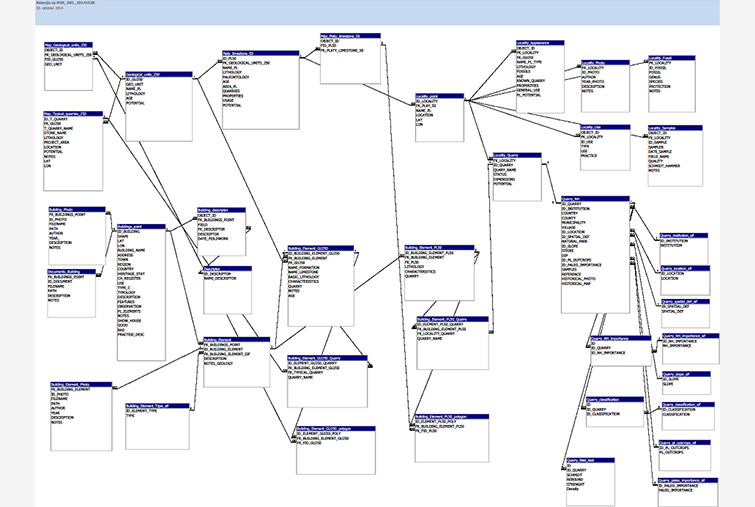
The RoofOfRock database is structured as different sections that are interrelated. It contains 16 tables and 15 spatial data layers in three main sections: geology, studied objects as cultural heritage, and natural heritage as limitations and guidelines (Table 6.1). The geology section represents geological overview data at a scale of 1:250,000 and platy limestone data at a scale of 1:50,000. It consists of geological maps, quarries and platy limestone localities. In the studied objects section is all of the data on the selected objects constructed of platy limestone, especially the 26 case-study objects. This section has 11 relational tables that describe the studied objects with basic descriptions, photographs and documents, and detailed descriptions of object elements and related construction materials with spatial and geological origin.
The tables and feature classes of the RoofOfRock geodatabase are organized as a relational conceptual model. Below is a representation of this conceptual model where the complexity of geodatabase relations can be seen (Fig. 6.2). There are 28 relationship classes in the final geodatabase.