Activities have been carried out in collaboration with WP6 outputs and concern data on all protected areas. A Geodatabase contains the entire geographical dataset in terms of all data collected for Slovenian, Italian, Croatian and Bosnia and Herzegovinan study areas.
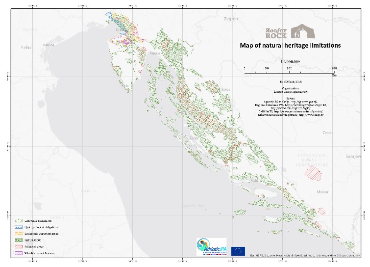
The spatial distribution of the laws and obligations spread over the project study area, together with a thorough knowledge of the regulations, is crucial for assessing the possibility of exploiting platy limestone from new or existing quarries (Map 4.1).
Map 4.1 Existing legislation covering natural heritage and protected areas in the RoofOfRock project area
The legislation in force covering the natural heritage in all countries has been revised, classified and grouped in order to be inserted, as a simple code, inside the Geodatabase and in particular, in the data sheets that have been specifically developed for the quarries (Table 4.1).
ID_IMPORTANCE
Importance of national area/park where exploitation area/quarry is located
1
National
2
Regional
3
Local
4
NATURA 2K SCI
5
NATURA 2K SPA
6
GEOSITE
7
NONE
Table 4.1 List of laws and their relevance
Exploitation areas
This section illustrates the outputs of field activities and processing carried out for the analysis of platy limestone exploitation areas.
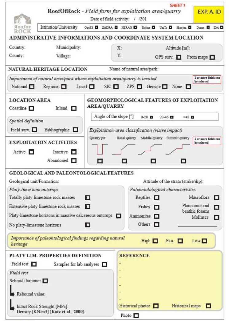
In order to characterize outcrops of platy limestone and possible potential sites for extraction, extensive field activities were performed in all countries in the framework of the WP3 and WP5. The outputs allowed the project team to inventory and characterize existing limestone quarries from a lithological, geomorphological, paleontological and legislative point of view, using a data sheet elaborated by DMG-UniTS in collaboration with GeoZS (Fig. 4.5).
In addition to general information about the location of the quarry and its status, the field data sheet requires distinguishing between four types of platy limestone outcrops (“totally platy limestone rock masses“, “extensive platy limestone rock masses”, “platy limestone horizons in massive calcareous limestone” and “no platy limestone horizons”), in order to assess the potential of the quarry in terms abundance of platy limestone. On the other hand, in the framework of the WP3, the potential of platy limestone spatial occurrences (polygons) was classified according to four categories: no potential, low potential, potential and high potential.
Applicable laws and obligations and their relevance according to Table 4.1 is also indicated.
Particular attention was devoted to paleontological findings. The data sheet lists the most common fossils in the Adriatic Dinaric Carbonate Platform, and has been inserted together with a simple methodology of fossil quality assessment. The latter considers three types of “Importance of paleontological findings regarding natural heritage”: high, fair and low. Further, the geomorphological characteristics of the quarry have also been described.
The field form data sheets assembled by the researchers have been inserted in Excel documents and have been stored in the Geodatabase.
Figure 4.5 The field form used in the surveying of exploitation areas
Italy
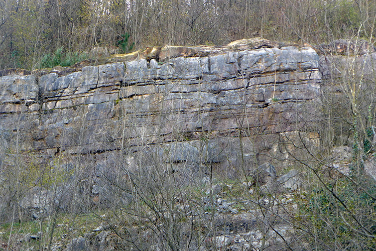
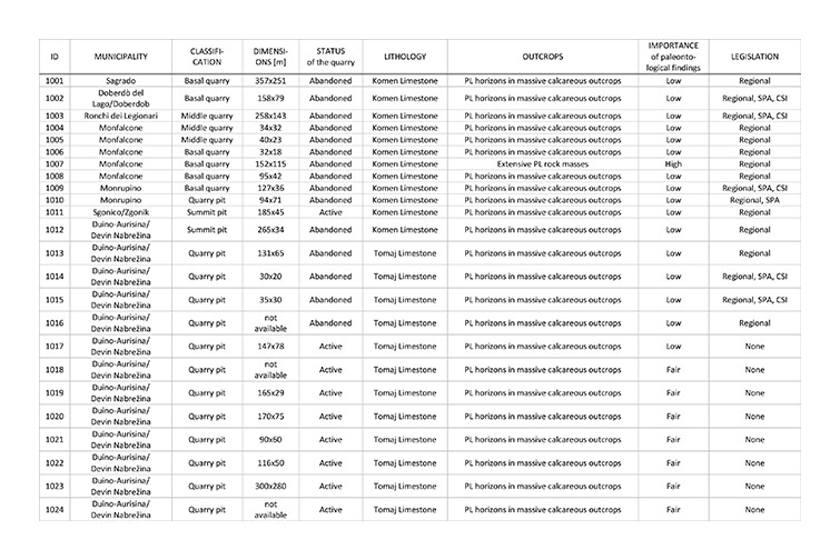
In the Italian part of the Carso/Kras, there are 124 quarries, which exploited or are currently exploiting limestones belonging to all of the geological units (see Appendix 2.1). Among them, 14 quarries are active and are working under the concession from the Geological Survey of the Friuli Venezia Region; 99 are inactive or completely abandoned, while 11 have been used as dumping sites. Due to the abundance of high quality massive limestone in the Italian Carso/Kras there are no quarries exclusively exploiting platy limestone. However, the field activities carried out in the framework of the geological (WP3) together with the legislative (WP5) actions expected to come out of the RoofOfRock project also allowed for the recognition of some platy limestone horizons and to define their potential (Figs. 4.6 and 4.7; Table 4.2).
Figure 4.6 Quarry with platy limestone layers in Gorizia County (Ferletti, Puia quarry)Figure 4.7 Platy limestone belonging to the Komen Limestone in Gorizia County (Monfalcone, Via Romana quarry). This quarry is abandoned. Due to the rich and particular paleontological findings, the speleological team of Monfalcone set up an educational panel.Table 4.2 List of quarries with horizons of platy limestone in the Italian part of the Carso/Kras
Slovenia
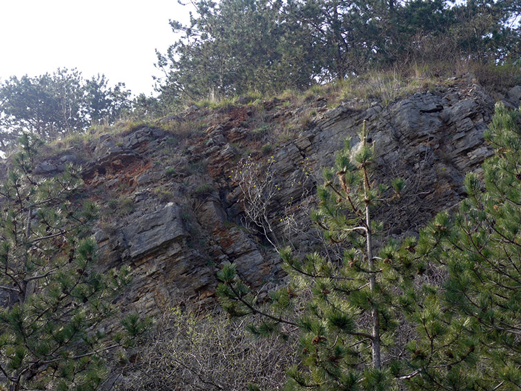
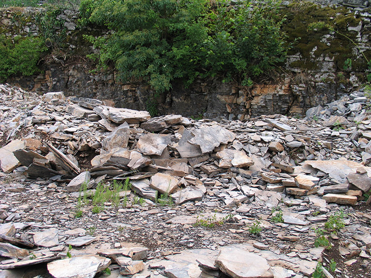
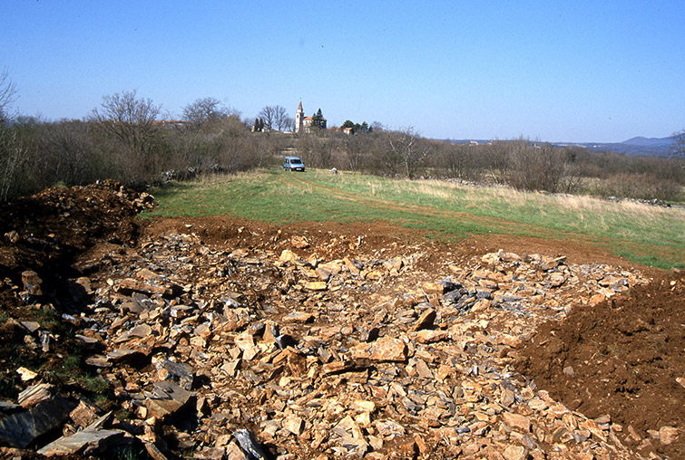
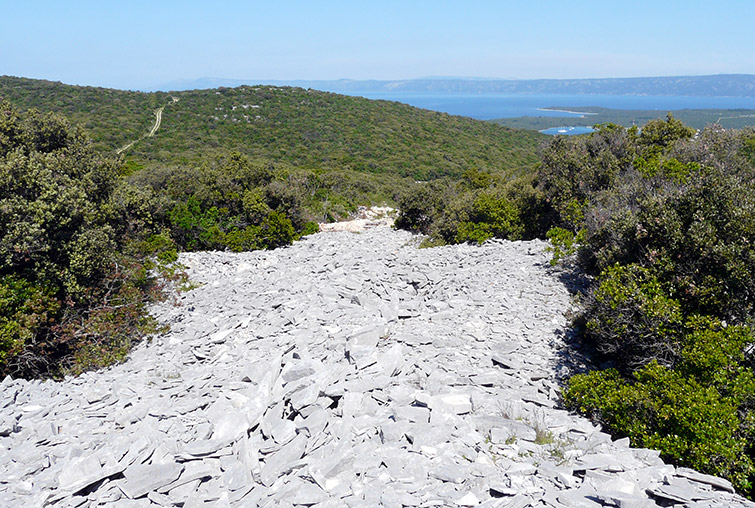
Platy limestone outcrops are relatively abundant in the Slovenian part of the Kras/ Carso, especially in the wider area of Škrbina, Sveto, Tomačevica and Gabrovica (Figs. 4.8 and 4.9).
Figure 4.8 Surface excavation of Komen platy limestone of Povir Formation near Gabrovica (Kras/Carso, Slovenia)
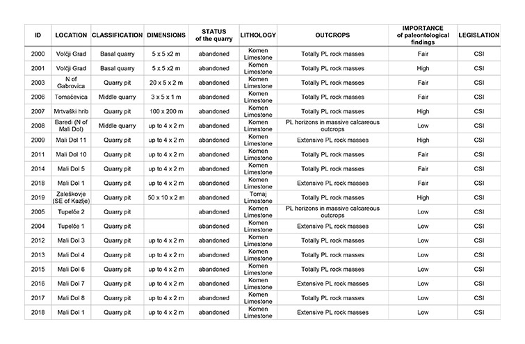
The expert team of the lead beneficiary Geological Survey of Slovenia (LB-GeoZS) recognized 21 abandoned quarries (Table 4.3) of platy limestone, most of them characterized by extensive platy limestone rock masses. All quarries lie in areas protected under the Natura 2000 network scheme, but are now abandoned.
Platy limestone of the Komen type is exposed also in the wider area of Pliskovica, Kopriva and Skopo, whereas the third area (Tomaj platy limestone) can be tracked from the village of Krajna vas across Dutovlje, Tomaj, Križ, and from the village of Dobravlje to Kazlje.
In all of these areas, limestone slabs were collected and extracted directly from the surface or immediately below it (Fig. 4.9). Slightly larger quarries or excavations were rare, and as a rule usually followed platy limestone by the strike of strata.
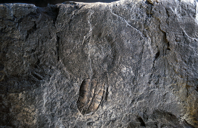
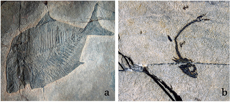
During excavation, fossils of vertebrates (fish and reptiles) were often found, which are now housed in museums across Europe. Their paleontological content is documented in the results of field activities carried out by GeoZS: most of the quarries are characterized by the presence of important fossils. In recent decades, intensive paleontological researches has led to many new discoveries of ammonites (Fig. 4.10), fishes (Fig. 4.11), echinoderms, plants and other fossils.
In the project area in Slovenia there are some 65 localities featuring rich fossil findings. Paleontological analysis of the platy limestone in the area represents an important part of geological heritage, and can limit large-scale commercial excavation efforts of platy limestone.
Figure 4.9 Surface excavation of the Komen limestone near Gabrovica (Kras/Carso, Slovenia)Figure 4.10 Ammonite belonging to the Placenticeratidae family with the aptychus, Tomaj limestone, Zaleškovje quarryFigure 4.11 Fish fossils in Komen Limestone: a) Komen village, b) Gabrovica (Kras/Carso, Slovenia)
In some parts of Kras/Carso, a fractured limestone is used for roofing, given that from a paleontological point of view it does not represent any particular natural value. In most cases it is a fractured, thick-bedded limestone of the Repen and Lipica formations. Owing to its mechanical characteristics the Repen formation is the most appropriate type of limestone for roofing (for detailed description see Appendix 2.2). It may be necessary, in future, to focus primarily on acquiring this type of limestone from those areas nearest to already active quarries, like the Tavčar quarry situated near Povir in the Repen formation.
Table 4.3 List of platy limestone quarries in the Slovenian part of the Kras/Carso
Croatia
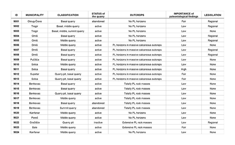
In Istra/Istria and part of Dalmatia 24 quarries have been surveyed and analyzed using the expert external IDA, ZADRA and RERA partners using the above-cited field form. The quarries are spatially distributed across the Istra/Istria peninsula and in areas around Zadar and Split (Table 4.4).
The majority of them are characterized by horizons of platy limestone.
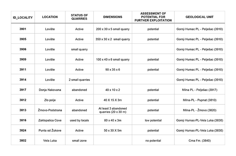
Abandoned limestone quarries and delves are also abundant in southern Dalmatia. Extensive field activities were carried out by the expert external DUNEA partner along the island of Korčula and the Pelješac peninsula (Table 4.5). Certain quarries have no potential for exploitation of platy limestone, but eight of them can be used. According to Table 4.5, most of the potential quarries are situated in the locality of Lovište in the north-western part of the Pelješac peninsula (Fig. 4.12). The quarries are largely small and not suitable for intensive exploitation.
Among the surveyed quarries of platy limestone, 16 lie within areas under the Natura 2000 network: 8 are active and are working under a permit, while the other 8 are abandoned. The conflicts occur on the outlying islands of Korčula, Pelješac, Hvar and Vis.
Figure 4.12 Large active quarry of Gornji Humac platy limestone at Lovište (Pelješac, Croatia)Table 4.4 List of quarries with horizons of platy limestone in the Istra/Istria, Zadar and Split areas in Croatia (prepared by IDA, ZADRA and RERA partner)Table 4.5 List of quarries with horizons of platy limestone along Korčula and the Pelješac peninsula in Croatia (prepared by DUNEA partner)
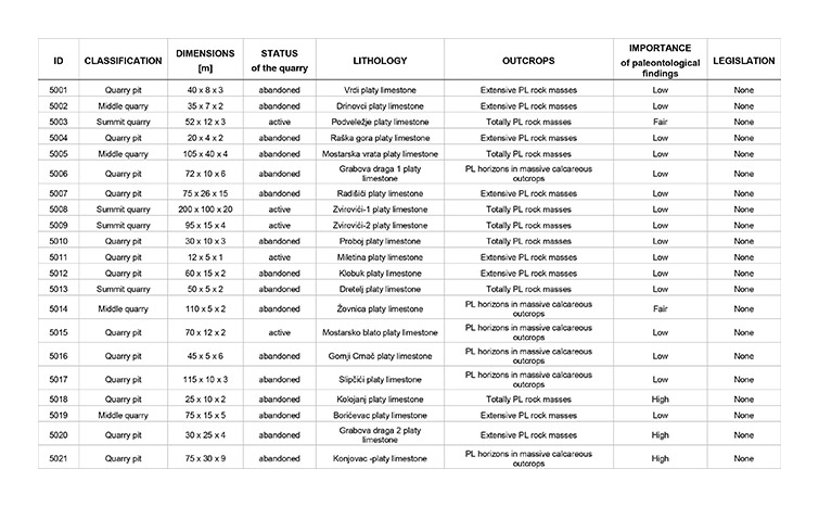
Bosnia and Herzegovina
The study area in Bosnia and Herzegovina includes the West Herzegovina County and Herzegovina-Neretva County. Experts from the HERAG’s external partner recognized and classified 21 quarries, 4 of which hold concessions for exploitation. Since the Natura 2000 network is not at present in place here the surveyed quarries are not in conflict with natural protection laws and obligations.
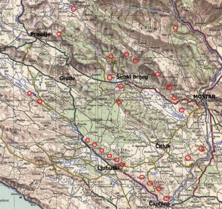
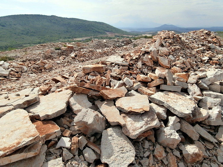
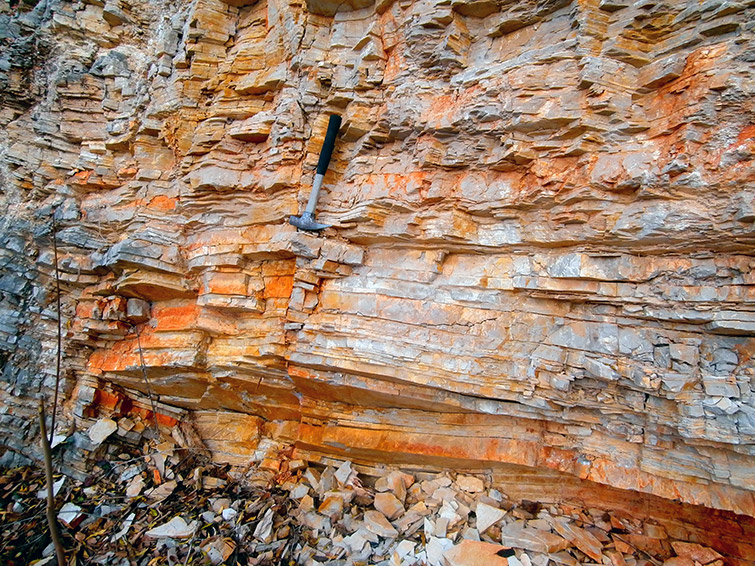
Figure 4.13 illustrates a map of platy limestone quarry sites, mainly distributed between Čapljina and Ljubuški, which are located south of Mostar. Quarries with concessions currently operate in the West Herzegovina County, whereas in the Herzegovina-Neretva County no concessionaires are present. The total number of quarries is very low considering the area and the resources available. Table 4.6, which follows below, lists the main properties of the quarries and the geological units exploited (Figs. 4.14 and 4.15).
Figure 4.13 Base map of platy limestone exploitation areas in western HerzegovinaFigure 4.14 Extensive active quarry of Zvirovići platy limestone (Herzegovina)Figure 4.15 Platy limestone in abandoned quarry at Proboj (Herzegovina)Table 4.6 List of quarries with horizons of platy limestone in the project area in Bosnia and Herzegovina
Platy limestone as natural heritage
Protection of quarries and other interesting sites