Platy limestone – geologic definition and its use as a mineral commodity
Jernej Jež, Uroš Barudžija, Sara Biolchi, Stefano Devoto, Goran Glamuzina, Tvrtko Korbar


Jernej Jež, Uroš Barudžija, Sara Biolchi, Stefano Devoto, Goran Glamuzina, Tvrtko Korbar
In the project area in Croatia, PL has been evaluated as a mineral commodity with respect to the general spatial limitations of its usage and its natural heritage. Due to the geological characteristics and huge spatial extent of the different PL types, only high-potential units and localities have been selected.
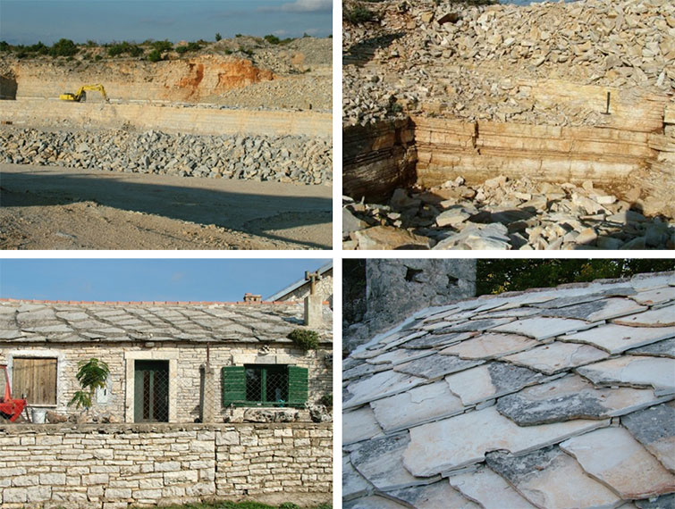
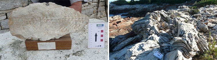
The main occurrence of PL in the Istrian County is within the generally high-potential Pula PL unit from the Albian age, and some minor occurrences in a few localities near Oprtalj, within Rušnjak PL from the Cenomanian age. Pula PL is of general high-potential just because of the very thin PL horizons which are sparsely distributed within the units. For this reason, more detailed research within this unit is needed. Both PL types were exploited in many delves, and used for roofing on the traditional rural houses and field shelters (Fig. 2.27).

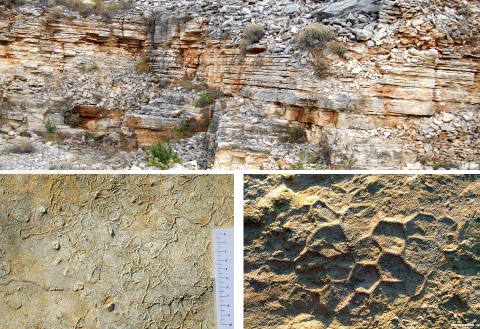
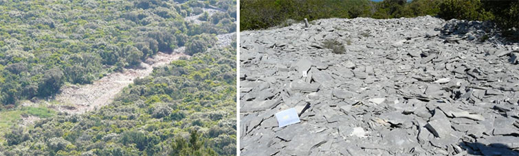
In the Zadar County (northern Dalmatia) there is a major PL occurrence within the Late Paleogene succession of the Promina unit commercially named “Benkovac Stone”. The stone is characterized by up to a few tens of metres thick PL succession (up to 100% of PL) that is rather uniformly very thin-bedded. The stone is still commercially exploited and widely used in Croatia (Fig. 2.28). Debelo brdo and Benkovac PL units are of excellent quality, since the PL is mostly densely packed micrite and fine-grained calcarenite.
The only restriction on the usage of the “Benkovac Stone” could be its yellowish colour which differs from other (mostly Cretaceous) greyish lithotypes of PL that characterize other parts of the project area in Croatia. Considering the Natura 2000 limitations, all the proposed high potential types in Zadar County are out of any protection category. Besides the widespread and famous cultural heritage, the “Benkovac Stone” maintains prominent geo-heritage features that could be protected within the proposed Vlačina geo-site (Fig. 2.29).
In Split-Dalmatia County (central Dalmatia), there are numerous, relatively small high-potential PL polygons, most of them are on the central Dalmatian islands. In the wider TROGIR area there are two high-potential polygons: the Kmečalovica area (W of Gustirna) and SW of Begovići village (Jelinak). On the island of ŠOLTA there are two high-potential polygons and one locality: Koludrovi doci, Kupište and Trzavica. On the island of HVAR there is a high-potential polygon of PL named Vrboska PL, located in the north-eastern part of Starogradsko polje which is already under cultural and natural protection, and can be additionally proposed as a future geo-touristic area. On the island of BRAČ there is a high-potential polygon east of Podgažul (northern slopes of Vidova gora) and Vestac locality (SW of Gornji Humac) (Fig. 2.30), while other are under Natura 2000 protection.
All the PL types are of very good to excellent quality. There are also other polygons and localities characterized by PL occurrence on the mainland and on the other islands (Veliki Drvenik, Vis). However, there are also spatial limitations for potential exploitation considering Natura 2000 and the restrictions for the islands. Many PL polygons and localities in the Split-Dalmatia County maintain prominent geological characteristics, which need to be appropriately presented to the public in the future. It must be pointed out that economic development is not always contrary to social development, since some of the PL sites and areas are much more interesting for landscape protection and geo-tourism than for the exploitation of mineral resources (e.g. Vrboska PL area on the island of Hvar and Rogač PL polygon on the island of Šolta) (Fig. 2.31).
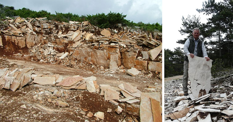
In Dubrovnik-Neretva County (southern Dalmatia), there is one big polygon and two relatively small high-potential PL polygons on the island of Korčula, and a few small polygons on the Pelješac peninsula, along with a few local occurrences. On the island of KORČULA there are three high-potential polygons: Vela Luka, Pupnat and Žrnovo. All the PL types are of good quality. On the W part of the PELJEŠAC peninsula (surroundings of Lovišta village) there are a few small polygons of the high-potential Gornji Humac PL-Pelješac type. One of them is characterized by artificial ridges and mounds of PL plates which are already prepared for use, probably as a result of major historical exploitation (Fig. 2.32).
Besides general spatial limitations of potential exploitation due to Natura2000, the proximity to the coast and settlements, as well as the position on the islands, we can especially recommend the area of Vela Luka as an outstanding landscape, developed within the major PL occurrence of Gornji Humac PL (Fig. 2.33).
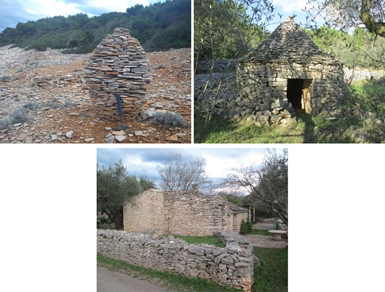
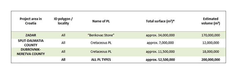
Table 2.6 summarizes the general evaluation of quantity of the PL as a mineral commodity, which approx. amounts to 200,000,000m3 for the three Dalmatian counties involved in the project RoofOfRock (see Appendix 2.3). However, current mining regulations in Croatia define special restrictions for the exploitation of mineral resources on the most of the islands. The Istrian County is also characterized by a significant PL potential, but numerical assessment is not possible without more detailed mapping of the huge spatial but dispersive appearance of PL within the Pula PL polygon.
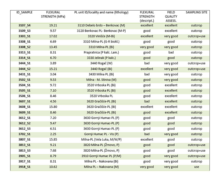
Following extensive field research, samples of selected PL types from the project area in Croatia were analysed for the purpose of a more precise petrological definition of PL, an interpretation of its origin, and an evaluation of its quality regarding the field assessment. The results, including the results of the flexural strength analyses measured in the IDA-METRIS laboratory (Annex 3.2), are presented in Table 2.7